Looks like the bulk of it hit to our south - Cliff Mass has an excellent post-mortem:
Extraordinary Lightning Strikes over the Northwest
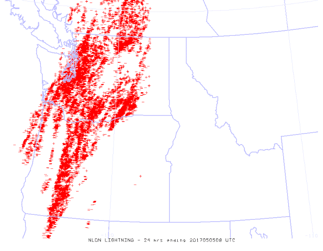
This morning, I took a look at the 24-h lightning strike map for the region and my jaw dropped (see the map below). Many hundreds (if not thousands) of lightning strikes hit our region, with southwest WA and the eastern side of Puget Sound country getting more lightning than I have ever seen before in a day. Simply amazing.
Why so much lighting for this event? Certainly, the record breaking amounts of atmospheric moisture streaming into the area the previous two days are prime candidates. Large amounts of moisture act like "fuel" for thunderstorms, since as the air rises in the cumulonimbus clouds, the moisture condenses, releasing latent heat, which makes the air more buoyant.
Another measure of the intensity of the thunderstorms yesterday were their heights. Typical thunderstorms around here usually rise to 15,000-20,000 feet at most. Wimpy stuff. But yesterday, several of the storms climbed to over 40,000 ft, as shown by the echo-top radar product shown below.
Cliff also had two other posts about this storm which make for fun reading on this epic weather event - here are links:
#1) - Thunderstorms Have Begun over the Northwest!
#2) - Amazing Day of Lightining
Puget Sound Electric reported upwards of 40,000 people without power at its height yesterday. They are reporting about 130 seperate outages totalling about 4,000 customers that are still out as of this posting.

Leave a comment