UPDATE at the bottom
From the National Weather Service Special Weather Statement:
...VERY STORMY WEATHER TO UNLEASH MULTIPLE IMPACTS ON WESTERN
WASHINGTON FROM THURSDAY THROUGH THE WEEKEND...
AN IMPRESSIVELY STORMY PERIOD IS COMING UP FOR WESTERN WASHINGTON
FROM THURSDAY THROUGH THE WEEKEND. THE MAIN IMPACTS WILL BE FROM
FLOOD-PRODUCING RAINFALL AND DAMAGING WINDS. ALONG THE COAST...
GIANT WAVES AND COASTAL FLOODING ARE POSSIBLE THIS WEEKEND.
RAIN WILL FIRST DEVELOP ACROSS WESTERN WASHINGTON TONIGHT...AND
BREEZY CONDITIONS WILL DEVELOP ALONG THE COAST.
HOWEVER...THE FIRST BIG INCREASE IN SOUTHERLY WIND WILL HAPPEN ON
THE COAST ON THURSDAY AFTERNOON...SPREADING INLAND ON THURSDAY
NIGHT. THIS WILL OCCUR FOLLOWING THE PASSAGE OF A DEEP LOW CENTER
THROUGH THE REGION. PLEASE REFER TO THE LATEST HIGH WIND WATCHES
AND WARNINGS FOR DETAILS ON THE THURSDAY NIGHT STORM. HEFTY
RAINFALL TOTALS ARE EXPECTED THROUGH FRIDAY MORNING...RAINFALL
AMOUNTS ARE EXPECTED TO BE: 1 TO 3 INCHES OVER THE INTERIOR
LOWLANDS...2 TO 5 INCHES ALONG THE COAST AND IN THE CASCADE
MOUNTAINS...AND 4 TO 8 INCHES OVER THE OLYMPIC MOUNTAINS. THIS
WILL CAUSE RISES ON AREA RIVERS...WITH FLOODING POSSIBLE ON A FEW.
REFER TO THE LATEST FLOOD BULLETINS FOR DETAILS.
FRIDAY WILL BE RAINY AND WINDY...BUT IT WILL SERVE AS A RELATIVE
LULL BEFORE A MORE POTENTIALLY DAMAGING STORM ON SATURDAY.
WE STILL HAVE MUCH TO LEARN ABOUT THE SATURDAY STORM. WHAT WE KNOW
IS THAT AN INCREDIBLY DEEP LOW PRESSURE CENTER...WITH ITS ORIGINS
TRACED BACK TO TYPHOON SONGDA IN THE WESTERN PACIFIC...WILL MOVE
INTO THE NORTHEAST PACIFIC AND PEAK IN STRENGTH ON SATURDAY.
WHAT REMAINS TO BE SEEN IS EXACTLY WHAT TRACK THE LOW CENTER WILL
TAKE. THIS WILL MAKE A HUGE DIFFERENCE IN HOW BADLY THIS STORM
IMPACTS WESTERN WASHINGTON. THERE IS A 1 IN 3 CHANCE OF THE LOW
CENTER DIRECTLY CROSSING SOME PART OF WESTERN WASHINGTON. THIS
WOULD BE A WORST CASE SCENARIO LEADING TO A HISTORICAL WINDSTORM
FOR NEARLY ALL OF WESTERN WASHINGTON THAT WOULD BE LONG
REMEMBERED.
THERE IS A 2 IN 3 CHANCE THAT THE LOW CENTER WILL PASS HUNDREDS OF
MILES OFF THE COAST...MAKING LANDFALL OVER CENTRAL OR NORTHERN
VANCOUVER ISLAND INSTEAD. THIS OUTCOME CONFINE THE MOST DAMAGING
WINDS TO THE COAST AND TO THE NORTH INTERIOR (AREAS NORTH OF
EVERETT)...BUT INLAND LOCATIONS SUCH AS THE PUGET SOUND REGION AND
THE I-5 CORRIDOR OF SOUTHWEST WASHINGTON WOULD EXPERIENCE THE TYPE
OF WINDSTORM THAT WOULD NORMALLY BE EXPECTED A FEW TIMES EACH
STORM SEASON. POWER OUTAGES AND TREE DAMAGE OVER INLAND LOCATIONS
WOULD BE LESS WIDESPREAD.
Ho. Li. Crap. Spending today and tomorrow battening down the hatches...
UPDATE: Cliff Mass has the goods - go here and read: Warning: Major Storms Threaten the Pacific Northwest
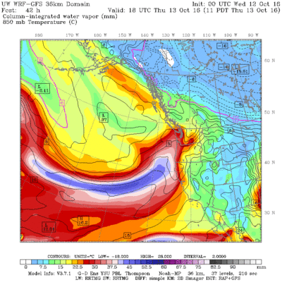
Here is just a small example of what is headed our way (click on image to embiggen):


Leave a comment