Article from Cliff Mass:
U.S. Extremes: Big Warm Ridge over the West and Deep, Cold Trough over the East
There is a lot of talk about extreme regional differences in politics these days, but during the next week, we will see amazing differences between the western and central U.S. in temperature:
A very strong ridge of high pressure will prevail over the West, with very warm temperatures aloft, while the east will be dominated by a deep trough of low pressure, that will bring extreme cold down to the surface.
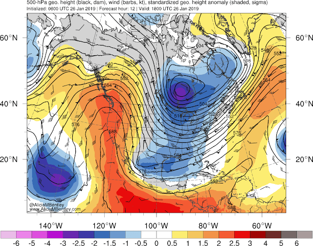
Let me start by showing you some very colorful maps created by Alicia Bentley (a NOAA/NWS employee!) These show the upper level maps (500 hPa pressure level, about 18,000 ft ASL), with the heights of the pressure level shown in black, and a measure of the differences (or anomalies) from normal shown in colors (orange/red are above normal, blue/purple below) normal.
Today at 10 AM (1800 UTC) there is a big ridge of higher heights (think high pressure) over the West Coast and a trough (lower heights/pressures) over the east. Major anomalies, with the purple colors indicating very usual low heights.
Continued freezing temps for the Midwest and East. Mild winter for the Pacific Northwest. We are really going to start feeling this around Wednesday the 30th. Wonder if Al Gore is in Chicago?

Leave a comment