We are going to get creamed. From Cliff Mass:
Two Snowstorms Down. The Big One Maybe Yet to Come!
The current snow event is nearly over and it appears that the forecast models did an excellent job.
Here are some of the latest snow accumulations from the National Weather Service (reported at 4:47 AM), noting that many of the reports were made before the storm was over. My house in NE Seattle had 4 inches. The range of snow was roughly 3 to 8 inches--very consistent with the forecasts. And there have been some extreme snowfalls, including a reported 21 inches near Port Angeles.
Being on the North end of the island has its advantages. I got about three inches from the first snowfall and 1.5" last night. There was a network of the emergency communications people this morning and people on the South end of the island had significantly more with one person getting 28" total from both storms. It is going to get cold and stay cold for the next couple of days and then this little bundle of joy shows up on our doorstep:
But then we must talk about the Big Kahuna of snow, comeing in early Tuesday, with a deep low center EXACTLY where it needs to be to give us snow (see sea level pressure forecast for 4 AM Tuesday). Any Northwest meteorologists knows what this means.
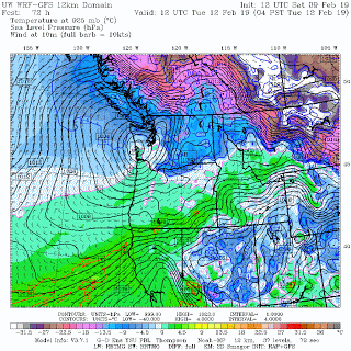
The snow total forecast for the 24hr ending 4 PM Tuesday is scary, with 8-12 inches of new snow coming into Puget Sound. HUGE amounts on the Oregon Cascades...we are talking FEET of snow.
Should we worry about this? Yes.
I am fully prepped for being snowbound - should be interesting to see what happens. Worst case scenario, I have plenty of propane and firewood, a very cozy bed and a couple of good library books. Radio and camera batteries are all charged up. Plenty of food in the pantry.

Leave a comment